

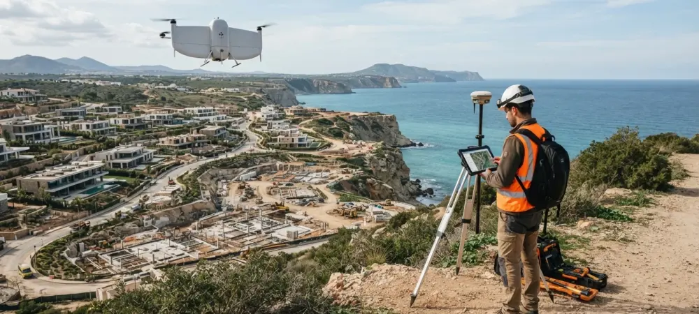
The rhythmic hum of a spinning Light Detection and Ranging sensor has replaced the quiet tapping of a scribe’s pen as the defining sound of a modern infrastructure project. This auditory shift signals a profound transformation in how humanity measures and understands its physical environment. On a typical morning in late 2026, a single professional stands at the edge of a multi-billion-dollar development site, not with a crew of assistants or a heavy transit, but with a ruggedized tablet and a fleet of autonomous systems ready for deployment. The era of manual labor in the field of geospatial measurement has effectively ended, giving way to a high-speed, high-precision reality that was once the exclusive domain of science fiction writers. This change represents the culmination of decades of incremental progress in sensor technology, satellite positioning, and machine learning, finally converging into a seamless workflow that prizes intelligence over brute force.
The professional landscape today is unrecognizable to those who left the field just a decade ago. Where a survey crew once spent weeks hacking through brush to establish control points and record topographic details, the same task is now compressed into a single morning. This “four-hour survey” is the new benchmark for the industry, enabling a speed of development that matches the rapid pace of global urbanization and the urgent need for environmental resilience. The modern surveyor no longer spends hours peer-to-peer with an assistant, shouting measurements across a busy highway or through dense forest. Instead, the surveyor acts as a commander of a robotic vanguard, orchestrating sensors that capture millions of points per second with sub-centimeter accuracy. This shift from manual measurement to data orchestration has not only boosted productivity but has also elevated the professional status of the surveyor from a technician to a critical manager of geospatial intelligence.
The Four-Hour Survey: From Science Fiction to Standard Operating Procedure
The transition to the four-hour survey model is not merely a quantitative improvement in speed but a qualitative change in how sites are documented. In the current environment, a professional arrives on-site and initiates a multi-layered data capture sequence. This often begins with the launch of a vertical take-off and landing drone, which autonomously maps the entire perimeter using a high-density LiDAR payload and a high-resolution photogrammetric camera. While the drone circles overhead, the surveyor walks the interior or obscured areas with a handheld SLAM device, which creates a three-dimensional model of the environment in real-time. This simultaneous acquisition of aerial and terrestrial data ensures that every pipe, pylon, and topographical feature is recorded before the first lunch break.
What makes this possible is the total integration of positioning systems that function without the traditional constraints of line-of-sight or clear sky views. The perfection of multi-constellation GNSS receivers, utilizing GPS III, Galileo, and BeiDou signals, allows for nearly instantaneous initialization even in challenging urban canyons. When satellite signals are obstructed, onboard inertial measurement units and SLAM algorithms take over, maintaining the spatial integrity of the data. This level of reliability has turned what used to be a high-stress gamble with the weather and signal availability into a routine, standardized procedure. The survey deliverable is no longer a static paper map or a simple CAD file; it is a rich, colorized point cloud that serves as the foundation for the project’s digital twin.
Moreover, the reduction in crew size from four or five individuals to a single operator has rewritten the economics of the profession. This lean operational model allows firms to handle a higher volume of projects while reducing the physical risk to personnel. In 2026, the sight of a surveyor standing dangerously close to high-speed traffic or scaling unstable embankments is increasingly rare. The ability to collect comprehensive data from a safe distance or through a robotic surrogate has turned surveying into one of the most technologically advanced sectors of the construction industry. As a result, the “four-hour survey” is no longer an ambitious goal; it is the baseline requirement for any firm looking to remain competitive in a market that demands real-time spatial awareness.
Beyond the Tripod: Why the Automation Pivot Matters Now
The move toward total automation is fueled by a confluence of global pressures that extend far beyond simple technical curiosity. Chief among these is a chronic labor shortage that has plagued the engineering and construction sectors for years. As the older generation of surveyors reached retirement age, the pipeline of new professionals struggled to keep pace with the exploding demand for geospatial data. Automation has bridged this gap, allowing the existing workforce to do more with less while attracting a new generation of tech-savvy professionals who are more interested in data science and robotics than in traditional land surveying. This demographic shift has forced the industry to rethink its tools, prioritizing ease of use and automated workflows over the specialized manual skills of the past.
Furthermore, the global mandate for climate change adaptation and environmental monitoring has created a need for “living” datasets that a tripod-based approach simply cannot provide. Whether it is monitoring coastal erosion, tracking the health of forests, or ensuring the stability of aging infrastructure, the requirement is for continuous, high-frequency data. Traditional surveying was a “snapshot in time” that became obsolete the moment the crew left the site. Today, the world demands a continuous stream of information to manage resources and mitigate risks. Automation allows for the deployment of permanent or semi-permanent sensors that provide real-time updates, transforming the survey from a periodic event into a persistent service that provides ongoing value to clients and society.
Finally, the pivot to automation is driven by the rise of the Digital Twin economy. In 2026, building owners, city planners, and facility managers are no longer satisfied with two-dimensional drawings. They require high-fidelity, three-dimensional models that are linked to real-time sensor data—a virtual mirror of the physical world. Creating and maintaining these twins requires an immense volume of data that can only be captured and processed through automated means. This has moved the surveyor into the role of a data engineer, responsible for the accuracy and integrity of the digital foundation upon which entire smart cities are built. Understanding the state of play in automation is therefore essential because it defines the very nature of professional accountability in a world where digital and physical realities are inextricably linked.
The Technological Frontier: Hardware, Autonomy, and Artificial Intelligence
The hardware stack of 2026 represents the pinnacle of miniaturization and computational power. Robotic Total Stations are now so advanced that they can differentiate between a surveyor’s prism and a reflective vest on a crowded construction site with perfect reliability. These instruments are essentially intelligent robots capable of autonomous tracking, self-calibration, and remote operation via 5G connectivity. Meanwhile, the rise of wearable SLAM technology has turned the surveyor’s own body into a mobile mapping platform. By simply walking through a complex industrial facility, a professional can capture a millimetric-accurate 3D model, with the onboard computer processing the data as they move, providing immediate feedback on data quality and coverage.
On the robotic front, the deployment of uncrewed platforms has moved from experimental trials to standard production. In the mining sector, autonomous drones now regularly descend into deep ore passes and unmapped stopes to monitor structural integrity and calculate volumes without human intervention. These drones use sophisticated obstacle avoidance and light-independent sensors to navigate the most hostile environments on Earth. Similarly, in the maritime world, Uncrewed Surface Vessels have become the preferred tool for mapping the seabed and inspecting offshore wind farm foundations. These vessels can stay at sea for weeks, controlled from remote operations centers located thousands of miles away, drastically reducing the carbon footprint and cost of traditional hydrographic missions.
Perhaps the most significant leap, however, has occurred in the realm of artificial intelligence and geospatial foundation models. In the office, the grueling task of manually classifying billions of points in a LiDAR cloud has been replaced by AI algorithms that can identify trees, power lines, curbs, and building facades with higher precision than a human operator. These foundation models, trained on petabytes of global Earth observation data, allow surveyors to query their data in natural language, asking for specific feature extractions or volumetric changes between two survey dates. This shift from manual drafting to AI-assisted analysis has moved the bottleneck of the surveying process from the computer screen to the final stage of professional validation, allowing for a near-instantaneous turnaround of complex topographic reports.
Professional Judgment and the Human Bottleneck
Despite the overwhelming presence of machines, the core of the surveying profession remains anchored in human judgment, particularly where the law is concerned. The determination of a property boundary is not a simple measurement task; it is a complex legal interpretation of historical evidence, conflicting deeds, and physical markers that may have moved over centuries. No algorithm in 2026 can weigh the intent of a nineteenth-century land grant against the physical presence of a modern fence line or a meandering stream. Because a licensed professional carries personal legal liability for cadastral work, the machine remains a tool, while the human remains the arbiter of truth. This legal firewall ensures that even as the “how” of measurement changes, the “who” remains a qualified professional.
Quality assurance serves as the second major human bottleneck in the automated pipeline. While a robot can collect a billion data points, it cannot inherently understand the context or the specific accuracy requirements of a unique engineering project. A human surveyor must validate the data against established international standards, ensuring that the coordinate system is correct and that any sensor drift has been properly accounted for. This role of the “Surveyor of Record” has become more critical as the volume of data grows. Without human oversight, the “garbage in, garbage out” principle could lead to catastrophic failures in multi-billion-dollar infrastructure projects. The professional’s signature is the final safeguard that confirms a dataset is fit for its intended purpose.
Furthermore, the ethical implications of automated data collection require human intervention to navigate. Issues of privacy, data ownership, and the potential for surveillance are constant concerns in an era where drones and mobile scanners can document every inch of a city. The modern surveyor must be well-versed in the ethical frameworks governing geospatial data, ensuring that the capture of information does not infringe upon the rights of the public. This necessitates a level of empathy and social awareness that artificial intelligence has yet to replicate. As the industry continues to automate, the value of this human “expert opinion” has actually increased, as it provides the necessary trust and transparency required for public and private stakeholders to act on the data provided.
Strategies for the Modern Geospatial Intelligence Manager
For the geospatial manager operating in 2026, the primary strategy for success involves a transition from being a hardware specialist to becoming a data architect. The most successful firms are those that have moved away from selling “hours in the field” and have instead embraced a “geospatial as-a-service” model. By providing clients with continuous access to updated digital twins and automated progress reports, these firms create recurring value and deeper partnerships. This requires a significant investment in cloud infrastructure and data engineering talent, as the ability to manage, store, and analyze massive datasets is now just as important as the ability to collect them in the first place.
Choosing a strategic position in the bifurcated market is another essential consideration for the modern professional. One path involves aggressive investment in the full technology stack to dominate high-volume, routine work such as construction site monitoring and large-scale topographic mapping. The other path focuses on high-margin, “judgment-heavy” niches where automation is less effective, such as complex forensic surveying, high-precision engineering consultancy, and legal boundary dispute resolution. Trying to occupy the middle ground—using semi-automated methods for routine work—is a recipe for obsolescence as the cost of fully automated competition continues to fall. Firms must decide whether they are a high-speed data factory or a high-level consultancy.
Finally, the modern manager must prioritize the integration of environmental and social metrics into their deliverables. In 2026, clients are increasingly looking for data that helps them meet sustainability goals and demonstrate environmental stewardship. Using automated systems to map carbon sequestration in forests, monitor the thermal efficiency of buildings, or track the resilience of coastal defenses provides a higher level of service that aligns with global economic trends. By leveraging “drone-in-a-box” systems and resident sensors, surveyors can provide the continuous monitoring necessary for these initiatives. The goal is to move from being a provider of maps to being a provider of insights, helping clients navigate a complex and rapidly changing world through the power of precision measurement.
The surveying profession arrived at a definitive crossroads during this period of rapid technological integration. The industry demonstrated a remarkable capacity to absorb the most advanced robotics and artificial intelligence while simultaneously reinforcing the importance of human professional standards. As the tools became more autonomous, the responsibility of the surveyor shifted toward the verification of data and the interpretation of complex spatial relationships. This era proved that while machines could measure the world with unprecedented speed and accuracy, they could not replace the nuance of legal interpretation or the ethical weight of professional accountability. The successful firms were those that recognized this early, investing in the automated pipelines required for scale while doubling down on the expert judgment that defined their value to society. Moving forward, the profession entered a new state of stability, characterized by a focus on the maintenance of digital twins and the support of global sustainability efforts through high-frequency geospatial intelligence. The surveyor’s role evolved into that of a vital curator of the physical and digital overlap, ensuring that the foundations of the future were as accurate as they were innovative.